Arcade Creek Bridge replacement

At long last, the crumbling bridge on Auburn Blvd. that crosses Arcade Creek is going to get repaired. It is a $16M project. Thanks to a federal grant, $9.2M was provided to the City of Sacramento for the project. The City of Sacramento is adding additional funds and, apparently, Sacramento County is providing some as well. Our Newsroom elves have been unsuccessful at getting County DOT to say how much money the County is kicking in, perhaps because of the odd arrangement at the project site whereby the city is responsible for Auburn Blvd. and the dotted line that defines the unincorporated area apparently begins at the edge of the pavement on the side away from Del Paso Park. It feels weird that the City of Sacramento is in charge of a roadway project, the impacts of which are almost 100% felt by county residents, but that's what happens when the City of Sacramento annexes adjacent unincorporated territory for city business reasons (the parcel across the street from SR244 was annexed in 1963 along with Swanston Estates on the west side of Ethan), rather than to meet community needs. Regardless, it makes obvious good sense to fix the 98-y.o. bridge.
The current configuation of the road network in the immediate vicinity of the project is, let's just say, complicated. As anyone who drives through there during commute hours can tell you, that's putting it mildly. Auburn Blvd. used to be the "Auburn Highway", the most significant E-W roadway between Northern California and the rest of the country. The I-80 freeway now bears that distinction. The Capital Cities freeway merges with I-80 at State Route 244, the short freeway stub that links Auburn Blvd. NE of Arcade Creek with the freeways. Winding Way handles E-W traffic on the other side of Arcade Creek, from Auburn Blvd eastward into the unincorporated suburban area. According to the FAQ page for the project, almost 31,000 vehicles travel across the bridge each day to access Auburn Blvd. and Winding Way. And the project will require closing Auburn Blvd. at the bridge for 3 months (or more?) starting after Memorial Day. So it is a big deal when all those vehicles have to take a detour all summer long, especially if the detour involves other congested, heavily-travelled roadways like Watt and Madison. The project is being managed by the City of Sacramento, which has a web site with project information. one Supervisor Desmond has cited in one of his recent email blasts.
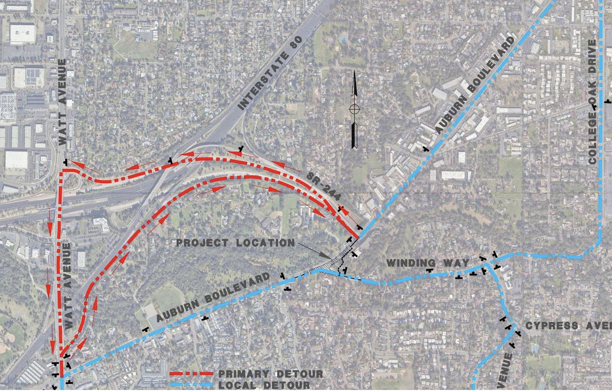
The bridge was originally built in 1927. It was widened to its present configuratation in 1965. The new project (see the drawing below) will widen the bridge from 76 feet to 100 feet, enabling some relief for the left turn congestion that plagues the intersection at Winding Way. It will also include sidewalks and bike lanes. During the project there will be a temporary pedestrian and bike crossing between Winding Way and Auburn Blvd. on the other side of the creek.
Taking a 70-foot-long bridge out of commission for 3 months will cause a summer of pain for people who would otherwise be able to travel through the project site. After it is completed, the situation is supposed to be better. Note that we said "better". That's different from "fixed". You see, as with just about every other physical configuration of the developed infrastructure that has been touched by the County around here, what we have now is the legacy of decades of failure to plan for the future. Mistake after mistake has led to a discombobulated land use pattern overlain by a dysfunctional transportation system, one that depends of cars for mobility. There isn't a valid public transportation system in the vicinity of the project site. Sidewalks and bike lanes don't mean anything absent a full system solution; the shiny new ones at the reconstructed bridge ultimately will fizzle out when pedestrians and cyclists reach the inevitable sidewalk and bike lane gaps that exist beyond the project site. Still, it is a good thing that the bridge is getting fixed and it is appropriate that the reconstructed bridge will have sidewalks and bike lanes. Our advice for the summer of pain, though, is: "Don't drive in '25".
